Michigan Central Station - Construction photos
Michigan Central Station

On May 16, 1910, the City of Detroit issued building permits for construction of Michigan Central Station (MCS). Michigan Central Railroad's new Detroit River Tunnel (construction of which determined the MCS site) was completed six weeks later, on July 1, 1910. As the MCS Office Tower was being topped out, completed segments of the station's 18-track elevated viaduct advanced northeastward, toward the terminal's still-skeletal Main Concourse (left). MCS opened on the afternoon of December 26, 1913, shortly after M.C.R.R.'s previous rail passenger terminal fronting on Third Street (today's Steve Yzerman Drive) caught fire. This November 27, 1912 Burton Historical Collection photograph was retrieved from Detroit Public Library - Caption by Peter Dudley (https://www.facebook.com/groups/100654233396758)

Michigan Central Depot in 1913, showing the top floors still under construction.

Michigan Central Depot in 1913, showing the top floors still under construction.

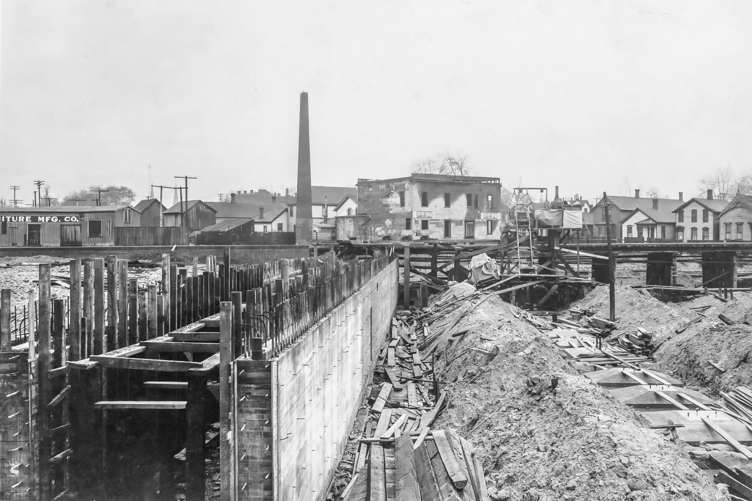
This c. 1910 Arthur Lyman Sarvey photograph shows the EAST side of the Michigan Central Station Viaduct's public pedestrian tunnel / east abutment -- which hasn't been seen since it was back-filled and buried, c. 113 years ago. There's an interesting projection from the concrete wall at about the half-way mark. The structure implies a future eastward extension of steel bridgework, as if the abutment would later serve as a bridge pier. In the distance, note the wooden pilings elevating the temporary mainline running to-and-from the recently-completed Michigan Central Railroad (M.C.R.R.) Detroit River Tunnel. This temporary bridgework ran through the future site of the long-gone Express Freight Offices, which perched atop the still-extant loading docks adjoining Newark Street. There's no sign that construction of permanent reinforced-concrete elevated trackways had started. A burned-out wood-frame building stood near the Newark end of the tunnel / abutment, featuring "Tip-Top Bread" signs. The tall chimney (left) was soon felled, collapsing at an angle across unpaved Newark. The original total length of the tunnel / abutment segment underneath MCS Tracks 1 through 18 was c. 343 feet - Caption by Peter Dudley (https://www.facebook.com/groups/100654233396758)

Looking north from the main train shed's foundation

Looking northwest from near 16th Street

Looking southwest over the excavation for the main shed.

Looking southwest over the footings of the main shed

This Detroit Publishing Company (DPC) image was entitled "Excavating for new Union Station". Before the landmark was completed, there was an expectation that ALL of Detroit's inter-city passenger trains would be hosted there -- that never happened. Part of the Michigan Central Station Viaduct (right), completed in 1910, elevated Michigan Central Railroad's double-track mainline, running to-and-from the Detroit River Tunnel (completed July 1, 1910). Note the light-shaded, reinforced-concrete structure, visible in the distance -- that was the first segment of the viaduct completed across (under) all eighteen tracks. This public pedestrian tunnel connected Newark Street with 15th Street, at the far southeast end of the bridgework. MCS passenger platform Track 1 eventually crossed atop the visible stub-end of the tunnel (center). The landmark's Main Concourse, Office Tower, and General Waiting Room were completed farther to the left (where the steam shovels were still digging). Once the excavation was completed, a three-foot-thick concrete "mat" was laid down, before any steel work was erected. Soil tests had indicated a tendency toward liquefaction under pressure. More than a century later, MCS still floats on its concrete foundation - Caption by Peter Dudley (https://www.facebook.com/groups/100654233396758)

Construction photo dated April 22, 1910, of Michigan Central Station

The steel-truss framework elevated overhead-third-rail electric catenary, which supplemented outside-third-rail electrification (visible in the foreground). Electric locomotives could lose contact with the outside-third-rail when negotiating complex trackwork east of the station's Bush Train Shed (almost out-of-frame, left). Small pantographs could be raised to maintain continuous electrical power. Michigan Central Railroad's Detroit / Windsor Electric Zone was maintained continuously from July 1, 1910 through December 29, 1953, when a fleet of ten new Diesel-electric tunnel locomotives replaced the aging ALCo-GE electric tunnel motors. While it lasted, the zone succeeded in keeping steam locomotive smoke out of the nearby Detroit River Tunnel -- the location of which determined the MCS location. Beyond the catenary framework, the ascending approach toward the long-gone 15th Street overpass (right edge) is still-extant. The renovated ramp (equipped with mostly-new concrete retaining walls) has been permanently-closed to vehicular traffic. 15th Street Interlocking Tower (1910-1967) is almost-visible at the photo's faded right edge. The tower controlled the station's east passenger throat, as well as access to the tunnel. Note the "Lionel-style" gooseneck light pole, visible near the center of the photograph. These poles originally elevated extremely-bright carbon-arc lighting fixtures. One or two of these poles might survive near MCS (along with a few cast-iron bases), but probably not for long (Arthur Lyman Sarvey photo, July 14, 1919) - Caption by Peter Dudley (https://www.facebook.com/groups/100654233396758)
This concrete public pedestrian tunnel, stretching between 15th Street and Newark Street (in the distance, beyond the temporary elevated Michigan Central Railroad mainline), also served as the east abutment for the Michigan Central Station Viaduct (the largest railroad bridge ever completed in Detroit). This tunnel / abutment was the first part of the viaduct to be extended across (under) all 18 MCS tracks, c. 1910. Recent photographs show that the Fall 2021 demolition of all ten elevated passenger platform trackways at MCS left this public pedestrian tunnel intact (!) -- despite the tunnel's Newark Street portal having been blocked for many years. Note the tall chimney visible in the distance -- it, along with the burned-out bakery on Newark, were demolished not long after this photograph was shot. The north end of the tunnel (foreground) is located at Google coordinates 42.328009, -83.076849 (Arthur Lyman Sarvey photo, c. 1910) - Caption by Peter Dudley (https://www.facebook.com/groups/100654233396758)

Excavation for Michigan Central Station

Construction of Michigan Central Station

Construction of Michigan Central Station, with a chimney being felled to make way.

Footings for Michigan Central Station

Foundation work for Michigan Central Station

Michigan Central Railroad's No. X.970, a rail-mounted steam shovel, excavates at the north end of the reinforced-concrete public pedestrian tunnel / east abutment, just east of the future site of Detroit's landmark Michigan Central Station (MCS). 15th and 14th streets slant through the working-class neighborhood beyond, where Albert Kahn's Art-Deco Roosevelt Park Railway Mail Service Annex would open in 1936. The shovel was located near Google coordinates (42.328330, -83.076740), just south of the station's future streetcar / interurban trolley terminal -- which was paved-over for use as a parking lot in 1938 - Caption by Peter Dudley (https://www.facebook.com/groups/100654233396758)

This photograph shows construction of the angled 15th Street overpass, looking west from near the intersection of 14th and Baker (today's Bagley) streets. The soon-to-be-demolished remains of the wood-timbered Baker Street segment of the 1870s-vintage Double Bridge are visible in the distance (left). The functionally-obsolete Baker bridge was replaced by a new concrete-and-steel version c. 1910. The new 15th Street span intersected it near its center. Note the outside-third-rail electrification -- the tracks ran to-and-from Michigan Central Railroad's new-in-1910 Detroit River Tunnel (out-of-frame, left). Today's Bagley overpass replaced the previous bridge in 1977. The north abutment of the long-gone 15th Street span survived until May 2023, when it was replaced with a new concrete retaining wall. As recently as August 2021, a century-old antique wrought-iron station fence lined the sidewalk adjacent to the ramp's west retaining wall. The fully-renovated approach ramp re-opened near the end of May 2023 -- it's permanently-closed to vehicular traffic. Given that the ramp's original concrete retaining walls were mostly-replaced, the antique station fence disappeared, along with the old concrete to which it had been attached (Arthur Lyman Sarvey photo, c. 1910) - Caption by Peter Dudley (https://www.facebook.com/groups/100654233396758)

This c. 1910 Arthur Lyman Sarvey photograph looks northwest along Newark Street, shortly after the first permanent elevated tracks were constructed southwest of the future site of Detroit's Michigan Central Station (MCS). Temporary elevated tracks (supported by pilings) ran through the future site of the station's Express Offices, which later perched above the Express Freight Warehouse loading docks (located between Newark and MCS Track 18). The temporary tracks partially-obscured the permanent MCS Viaduct. The concrete retaining wall (lower-right) is still-extant. Note the right-angled corner of the wall, located a few yards southwest of the long-blocked entrance to the public pedestrian tunnel (leading under-the-tracks to 15th Street) - Caption by Peter Dudley (https://www.facebook.com/groups/100654233396758)

The depot under construction

A smiling young lady poses near a temporary construction track circling toward the East Entrance of Detroit's still-under-construction Michigan Central Station (MCS). The vertical wooden post in front of her appears to be a railroad tie. This photograph was shot late-1912 / early-2013, near 15th Street (visible on the right). The landmark opened on December 26, 1913 - Caption by Peter Dudley (https://www.facebook.com/groups/100654233396758)